Loch Lomond
Loch Lomond (/ˈlɒx ˈloʊmənd/; Scottish Gaelic: Loch Laomainn - 'Lake of the Elms') is a freshwater Scottish loch which crosses the Highland Boundary Fault, often considered the boundary between the lowlands of Central Scotland and the Highlands. Traditionally forming part of the boundary between the counties of Stirlingshire and Dunbartonshire, Loch Lomond is split between the council areas of Stirling, Argyll and Bute and West Dunbartonshire. Its southern shores are about 23 kilometres (14 mi) northwest of the centre of Glasgow, Scotland's largest city. The Loch forms part of the Loch Lomond and The Trossachs National Park which was established in 2002.
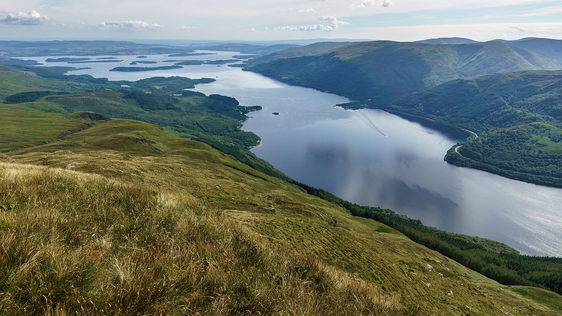
Loch Lomond is 36.4 kilometres (22.6 mi) long and between 1 and 8 kilometres (0.62–4.97 mi) wide, with a surface area of 71 km2 (27.5 sq mi). It is the largest lake in Great Britain by surface area; in the United Kingdom, it is surpassed only by Lough Neagh and Lough Erne in Northern Ireland. In the British Isles as a whole there are several larger loughs in the Republic of Ireland. The loch has a maximum depth of about 153 metres (502 ft) in the deeper northern portion, although the southern part of the loch rarely exceeds 30 metres (98 ft) in depth. The total volume of Loch Lomond is 2.6 km3 (0.62 cu mi), making it the second largest lake in Great Britain, after Loch Ness, by water volume.
The loch contains many islands, including Inchmurrin, the largest fresh-water island in the British Isles. Loch Lomond is a popular leisure destination and is featured in the song "The Bonnie Banks o' Loch Lomond". The loch is surrounded by hills, including Ben Lomond on the eastern shore, which is 974 metres (3,196 ft) in height and the most southerly of the Scottish Munro peaks. A 2005 poll of Radio Times readers voted Loch Lomond as the sixth greatest natural wonder in Britain.
Formation
The depression in which Loch Lomond lies was carved out by glaciers during the final stages of the last ice age, during a return to glacial conditions known as the Loch Lomond Readvance between 20,000 and 10,000 years ago. The loch lies on the Highland Boundary Fault, and the difference between the Highland and Lowland geology is reflected in the shape and character of the loch: in the north the glaciers dug a deep channel in the Highland schist, removing up to 600 m of bedrock to create a narrow, fjord-like finger lake. Further south the glaciers were able to spread across the softer Lowland sandstone, leading to a wider body of water that is rarely more than 30 m deep. In the period following the Loch Lomond Readvance the sea level rose, and for several periods Loch Lomond was connected to the sea, with shorelines identified at 13, 12 and 9 metres above sea level (the current loch lies at 8 m above sea level).
The change in rock type can be clearly seen at several points around the loch, as it runs across the islands of Inchmurrin, Creinch, Torrinch and Inchcailloch and over the ridge of Conic Hill. To the south lie green fields and cultivated land; to the north, mountains.
Islands
The loch contains thirty or more other islands, depending on the water level. Several of them are large by the standards of British bodies of freshwater. Inchmurrin, for example, is the largest island in a body of freshwater in the British Isles. Many of the islands are the remains of harder rocks that withstood the passing of the glaciers; however, as in Loch Tay, several of the islands appear to be crannogs, artificial islands built in prehistoric periods.
English travel writer, H.V. Morton wrote:
What a large part of Loch Lomond's beauty is due to its islands, those beautiful green tangled islands, that lie like jewels upon its surface.
Writing some 150 years earlier than Morton, Samuel Johnson had however been less impressed by Loch Lomond's islands, writing:
But as it is, the islets, which court the gazer at a distance, disgust him at his approach, when he finds, instead of soft lawns and shady thickets, nothing more than uncultivated ruggedness.
Flora and fauna
Powan are one of the commonest fish species in the loch, which has more species of fish than any other loch in Scotland, including lamprey, lampern, brook trout, perch, loach, common roach and flounder. The river lamprey of Loch Lomond display an unusual behavioural trait not seen elsewhere in Britain: unlike other populations, in which young hatch in rivers before migrating to the sea, the river lamprey here remain in freshwater all their lives, hatching in the Endrick Water and migrating into the loch as adults.
The surrounding hills are home to species such as black grouse, ptarmigan, golden eagles, pine martens, red deer and mountain hares. Many species of wading birds and water vole inhabit the loch shore. During the winter months large numbers of geese migrate to Loch Lomond, including over 1% of the entire global population of Greenland white-fronted geese (around 200 individuals), and up to 3,000 greylag geese.
The Scottish dock (Rumex aquaticus), sometimes called the Loch Lomond dock, is in Britain unique to the shores of Loch Lomond, being found mostly on around Balmaha on the western shore of the loch. It was first discovered growing there in 1936[23] (else it grows eastwards through Europe and Asia all the way to Japan).
One of the loch's islands, Inchconnachan, is home to a colony of wallabies.
Conservation designations
As well as forming part of the Loch Lomond and the Trossachs National Park, Loch Lomond holds multiple other conservation designations. 428 ha of land in the southeast, including five of the islands, is designated as national nature reserve: the Loch Lomond National Nature Reserve. Seven islands and much of the shoreline form a Special Area of Conservation (SAC), the Loch Lomond Woods. This designation overlaps partially with the national nature reserve, and is protected due to the presence of Atlantic oak woodlands and a population of otters.[26] Four islands and a section of the shoreline are designated as a Special Protection Area due to their importance for breeding capercaillie and visiting Greenland white-fronted geese: this designation overlaps partially with both the national nature reserve and the SAC. Loch Lomond is also a designated Ramsar site, again for the presence of Greenland white-fronted geese.
The loch and its surrounding are designated as a national scenic area, one of forty such areas in Scotland, which have been defined so as to identify areas of exceptional scenery and to ensure its protection from inappropriate development.
History
People first arrived in the Loch Lomond area around 5000 years ago, during the neolithic era. They left traces of their presence at several places around the loch, including Balmaha, Luss, and Inchlonaig. A number of crannogs, artificial islands used as dwellings for over five millennia, were built at points in the loch. The Romans had a fort within sight of the loch at Drumquhassle. The crannog known as "The Kitchen", located off the island of Clairinsh, may have later been used a place for important meetings by Clan Buchanan whose clan seat had been on Clairinsh since 1225: this usage would be in line with other crannogs such as that at Finlaggan on Islay, used by Clan Donald.
During the Early Medieval period viking raiders sailed up Loch Long, hauled their longboats over at the narrow neck of land at Tarbet, and sacked several islands in the loch.
The area surrounding the loch later become part of the province of Lennox, which covered much of the area of the later county of Dunbartonshire.
Loch Lomond became a popular destination for travellers, such that when James Boswell and Samuel Johnson visited the islands of Loch Lomond on the return from their tour of the Western Isles in 1773, the area was already firmly enough established as a destination for Boswell to note that it would be unnecessary to attempt any description.
Leisure activities
Boating and watersports
Loch Lomond is one of Scotland's premier boating and watersports venues, with visitors enjoying activities including kayaking, Canadian canoeing, paddle boarding, wake boarding, water skiing and wake surfing. The national park authority has tried to achieve a balance between land-based tourists and loch users, with environmentally sensitive areas subject to a strictly enforced 11 km/h (5.9 kn; 6.8 mph) speed limit, but the rest of the loch open to speeds of up to 90 km/h (49 kn; 56 mph).
The Maid of the Loch was the last paddle steamer built in Britain. Built on the Clyde in 1953, she operated on Loch Lomond for 29 years. She is now being restored at Balloch pier by the Loch Lomond Steamship Company, a charitable organisation, supported by West Dunbartonshire Council. Cruises also operate from Balloch, Tarbet, Inversnaid, Luss and Rowardennan.
Loch Lomond Rescue Boat provides 24-hour safety cover on the loch. The rescue boat is a volunteer organisation and a registered charity. The national park authority also have other boats on the loch such as The Brigadier. Police Scotland also operates on the loch using RIBs and jet skis and work in conjunction with the national park authority.
The loch has served as the venue for the Great Scottish Swim, which is held each year in August.
Angling
Fly and coarse fishing on Loch Lomond is regulated by the Loch Lomond Angling Improvement Association (LLAIA), who issue permits to members and visiting anglers. The association employ water bailiffs to monitor the actions of anglers on the loch and ensure angling is carried out in accordance with permit conditions.
Land-based activities
Loch Lomond Golf Club is situated on the south-western shore. It has hosted many international events including the Scottish Open. Another golf club, "The Carrick" has opened on the banks of the Loch adjacent to the Loch Lomond Club.
The West Highland Way runs along the eastern bank of the loch, and Inveruglas on the western bank is the terminus of the Cowal Way. The West Loch Lomond Cycle Path runs from Arrochar and Tarbet railway station, at the upper end of the loch, to Balloch railway station, at the south end. The 17-mile-long (28 km) long cycle path runs along the west bank.
At the southern end of the loch near Balloch is a large visitor and shopping complex named Loch Lomond Shores.
Access and camping
As with all land and inland water in Scotland there is a right of responsible access to the loch and its shoreline for those wishing to participate in recreational pursuits such as walking, camping, swimming and canoeing. In 2017 the national park authority introduced byelaws restricting the right to camp along much of the shoreline of Loch Lomond, due to issues such as litter and anti-social behaviour that were blamed on some irresponsible campers. Camping is now restricted to designated areas, and campers are required to purchase a permit to camp within these areas between March and October. The byelaws were opposed by groups such as Mountaineering Scotland and Ramblers Scotland, who argued that they would criminalise camping even where it was carried out responsibly, and that the national park authority already had sufficient powers to address irresponsible behaviour using existing laws.
Comments
Post a Comment